

Maps n Trax - Offline Maps, GPS Tracks & Waypoints app for iPhone and iPad
Developer: Rocket Splash Games
First release : 01 Nov 2012
App size: 37.05 Mb
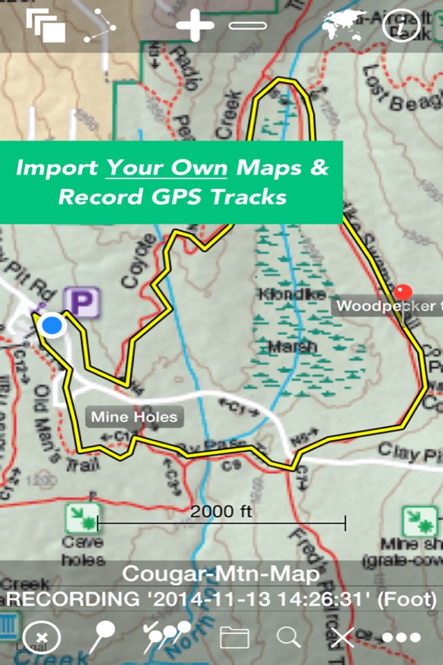
MAPS n TRAX is a VERSATILE and HIGHLY CUSTOMIZABLE offline map viewer, GPS track recording and WAYPOINT detail recorder.
* IMPORT AND VIEW YOUR OWN MAPS and GPS tracks on your device, and record tracks and detailed WAYPOINT notes. MAPS n TRAX excels in rugged "off the grid" professional, academic, and recreational activity on land, sea or air!
* GREAT SUPPORT! MAPS n TRAX is well-supported with a detailed online User Guide (http://rallyto.com/maps-n-trax/maps-n-trax-user-guide/) and responsive, personal email support.
With MAPS n TRAX you can:
• Import and view your favorite maps (see supported file formats below*).
• View your current GPS location on your imported map.
• Record GPS tracks.
• Record waypoint details including photographs and field notes.
• View maps and tracks superimposed on familiar online background maps.
• Import GPS tracks from other sources or export your track records.
• Easily store, organize and access multiple maps and track files.
Use MAPS n TRAX to view specialized map files, topographic maps, or digital map image files and gps tracks on your iOS device. You can even import scanned paper maps or photos of maps!
Even when far beyond the reach of cellular data or WIFI networks, with MAPS n TRAX you can view your own downloaded maps and use the GPS navigational features of your iOS device.
MAPS n TRAX has numerous professional applications. Our customers use the app to support forest fire fighting operations; environmental and biological field research; search and rescue; petroleum and mining; real estate; geo-truthing; flying; sailing; and, academic research. The off-the-grid functionality and waypoint recording features provide a powerful mobile toolset.
MAPS n TRAX is also ideal for a wide range of outdoor recreational including: bushwalking, hiking, trekking, bird watching, treasure hunting, prospecting, camping, bicycle touring, hunting, fishing, snowmobiling, dogsledding, 4-wheel drive off-road motoring, geocaching, orienteering, randonneuring, mountain biking, skiing (downhill, backcountry, Nordic), and squatching, among others.
Many publicly available maps can be imported into MAPS n TRAX. In addition the app is well suited for applications that require specialist maps with details that are customized or are not widely available, such as highly detailed topographic maps obtained from your government mapping authority or specialized maps produced with GIS tools.
Details:
• Converts and displays a wide range of map and image file types including * PNG, JPEG, TIFF, GIFF, ESRI Shapefiles, ESRI File Geodatabase and Open Street Map (PBF & XML) and geo-referenced image formats such as GeoTIFF. (Note: .ozf2 & .ozfx3 files are NOT supported). See the User Guide for more information about working with these files.
• Imports and exports tracks in GPX and KML formats.
• Compatible with raster and vector map file types and projections used in commercial and open source Geographic Information Systems (GIS) software tools including ARCGIS and OpenStreetMaps.
• Automatically align geo-referenced image files or manually calibrate non-geo-referenced ones.
• Can display large maps and can join several consecutive large maps into a single huge map. The map size is limited only by the iPhone or iPads storage capacity.
• Imported maps of different scales can be viewed simultaneously, adjacent to or overlapping each other.
• Multiple tracks can be displayed on maps simultaneously and tracks with named waypoints can be searched like a directory or gazetteer.
We recommend that you review our website www.rocketsplashgames.com/mapsntrax/support/ and the online User Guide to be sure that MAPS n TRAX suits your requirements. The User Guide section on Preparing Maps describes the process to prepare a plain image file for use as a location-calibrated and mobile-optimized map image.
Continued use of the GPS running in the background can dramatically reduce battery life on the iPhone or iPad.
Latest reviews of Maps n Trax - Offline Maps, GPS Tracks & Waypoints app for iPhone and iPad
the MapnTrax is very slow compared to BitMap. Please improve this. I use an iPhone4
Maps-n-Trax is useless for the function I need. I want to create waypoints in ArGIS, upload them to the iPhone and be able to navigate to them in the field. I can get the waypoints mapped but: 1) they appear and disappear erratically, 2) they dont function as waypoints (you have to drop a pin on them if you can find them) and 3) the "navigate to" function is primitive (indicates distance, and bearing but should switch to a clealry visible compass view).
This version does not open files from "Inbox"! Previous versions works very good!
Hi all! Firs of all, be warned that this software DOES NOT support ozi format even if it "jpeg/gif+map". Next, map calibration by drag and drop DOES NOT work. On "save" pressing the map jumps to 5-10 kilometers and changes zoom twice. Bitmap converter recommended and distributed by this program vendor, doing only one thing: it crashes on opening of ANY image file despite size, format etc. The only way to calibrate your own raster map is to use "2 point calibration" inside the program, but in this case map image MUST match several specific requirements not described in the manual. Be ready to program crash on attempt to delete some map. The manual is very obscure. It does not content any information about incoming data (images and calibration data) requirements nor illustrations or step-by-step examples.
For expert, very useful